Power of 32
- Details
- Hits: 6297
Power of 32
Connecting the Regional Trail Network
Power of 32 is the largest regional visioning initiative undertaken that engages thousands of people across 32 counties in Maryland, Ohio, Pennsylvania, and West Virginia to create a shared vision for a thriving future. One of the intended outcomes is to increase recreational opportunities and economic development related to greenways and a greater sense of regional connectedness. Hence, a key Power of 32-People & Community Goal is to create a comprehensive long-distance interconnected Regional Trail System.
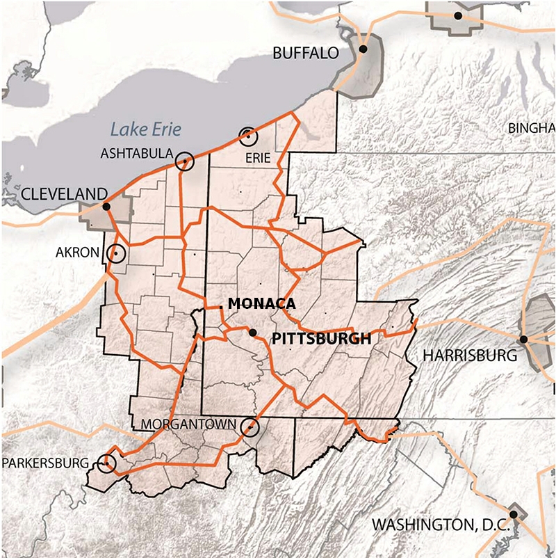
The Ohio River Greenway Trail Project is part of the Power of 32 Regional Trail Network Initiative, which is built upon past efforts to organize the trails community via the Tri-State Regional Trail Initiative. The Power of 32+ Regional Trail Network (working name, “P32” for short) is a planned multi-county, multi-state shared use system of connected trails.
A coalition of trail advocates has been formed to realize the vision, which includes government, non-profit and private foundation entities that are working together to position trail development as a regional priority. The Ohio River Trail Council as a member of the coalition has worked with its 18-partners in earnest over the last few years to define the trail corridors, to understand missing trail sections, and to develop mapping technology to support the effort. This technology is used to promote the trails and trail towns. A Geographic Information Systems (GIS) is a computer system used to capture, store, manipulate, analyze, manage, and present all types of spatial or geographical data. The regional network GIS trail data is continuously evaluated and updated on www.gototrails.com. The Pennsylvania Environmental Council is additionally developing a wayfinding app (now in beta form) that guides trail users to area trails and trail town amenities.
As of May 2014, the network has grown to include trails within a 53-county, 5-state area including MD, NY, PA, OH, and WV. Nearly 1,600 miles of shared use trails are mapped as part of the network. The system is 53% complete, including the renowned Great Allegheny Passage (GAP). Upon completion of the network, local and visiting trail users will be able to bike from trail to trail, city to city, and town to town.
Moving forward, the coalition will establish a branding and communications strategy (while not attempting to replace any existing trail brand identities); complete a trail gap analysis that assesses the viability of trail development and identifies related opportunities, costs, and barriers; and establish corridor working groups to address gaps in trail development. This effort is intended to support all of the on-the-ground trail planning, development, and maintenance that existing groups already lead by demonstrating that a system of trails, when completed and connected to each other, will yield unprecedented benefit to the region.
In 2015, the branding was completed and the Industrial Heartland Trails Coalition was established. For additional information, visit the Industrial Heartland Trails Coalition.